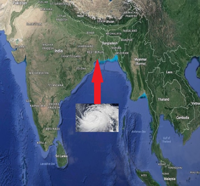
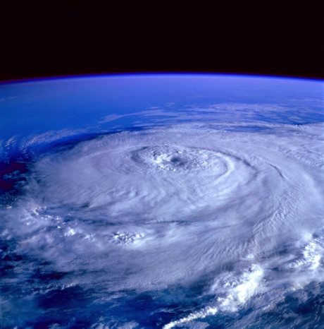
Cyclone ‘Yaas’; Another Disaster Anniversary Like Amphan; To Hit Odisha-West Bengal Coast by May 26
Cyclone ‘Yaas’, another natural anniversary disaster like Amphan is coming on 26th May 2021 to hit the coastal region of West Bengal and Odisha.
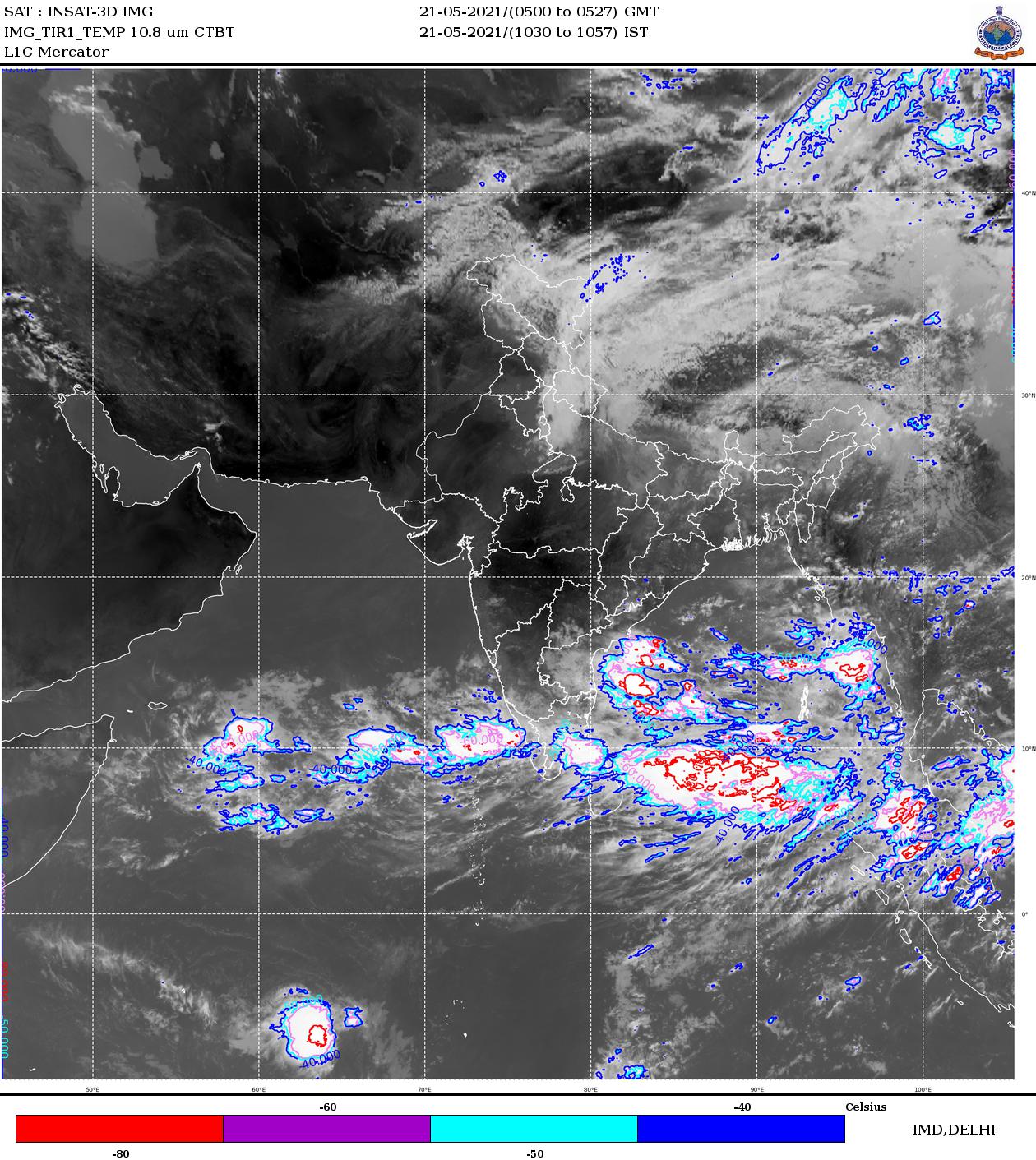
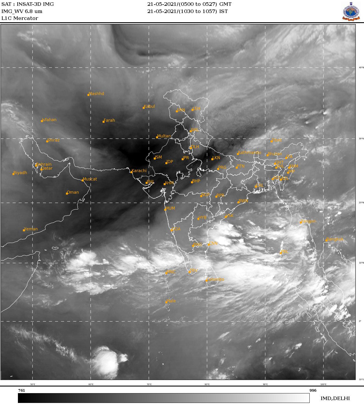
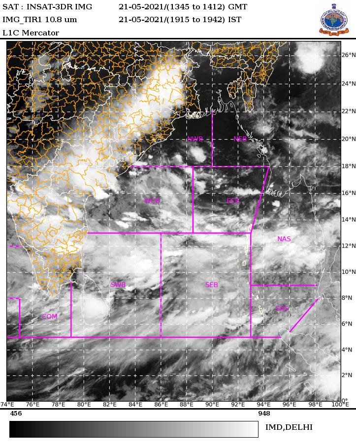
According to Indian Meteorological Department (IMD), cyclone ‘Yaas’ is likely to hit on next Wednesday (26/05/2021) to the coastal district of West Bengal and Odisha. The low pressure in the North Andaman Sea & adjoining East-Central Bay of Bengal on Saturday (21/05/2021) will gradually turn into a cyclone by storing energy.
Table of Contents
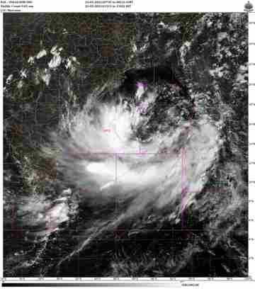
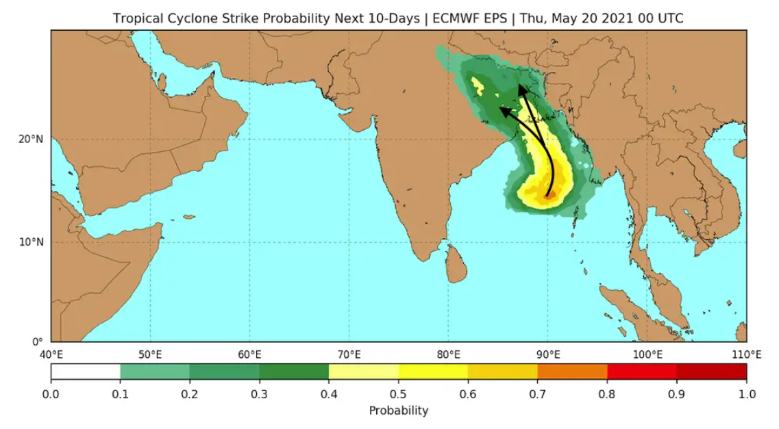
Latest Update: Tropical Cyclone Yaas Track Root
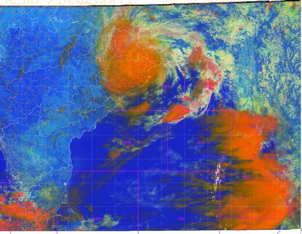
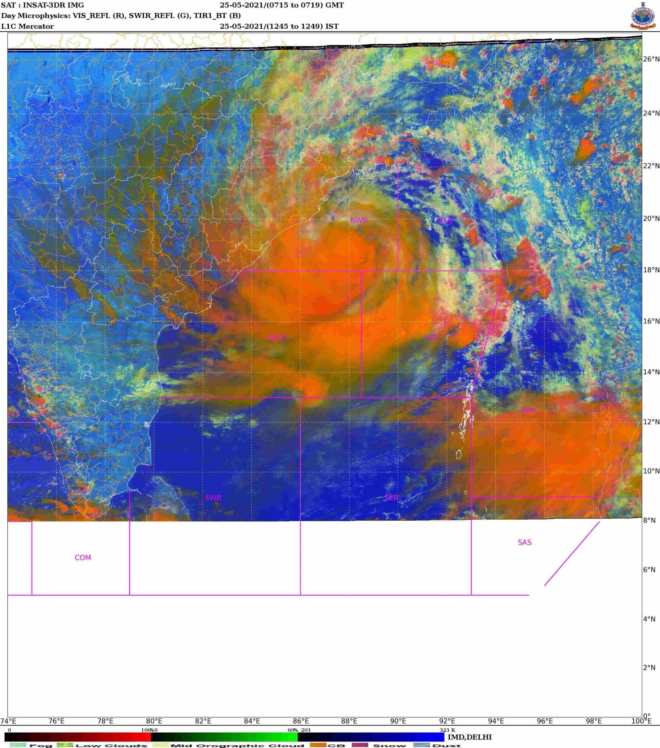
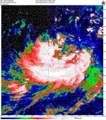
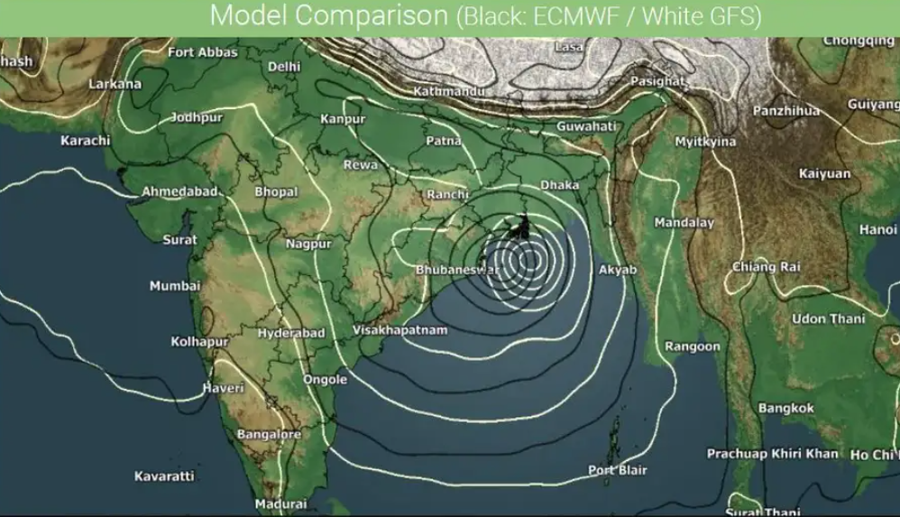
Possible Track Root of Cyclone Yaas by IMD on 26/05/2021
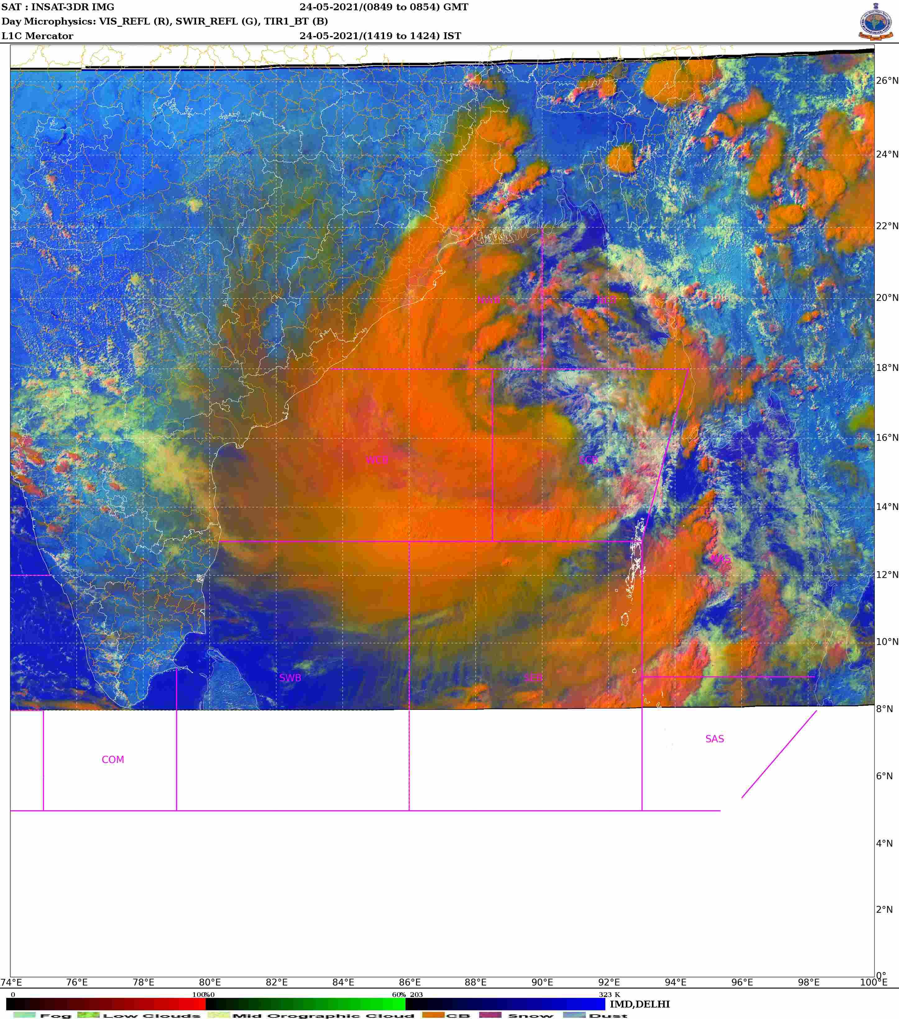
Possible Track Root of Cyclone Yaas by IMD on 25/05/2021
The ultimate landfall of cyclone Yaas will be the coastal region of West Bengal, Odisha, and Bangladesh.
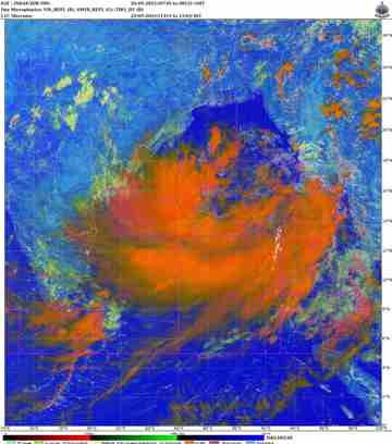
Rainfall Update in West Bengal and Odisha due to Yaas Cyclone

Cyclone Yaas: Live Update on 27/05/2021
Cyclone Yaas in Kolkata
Due to deep depression in Kolkata due to cyclone Yaas, heavy rainfall is going on. Sikkim, Uttarpradesh will also experience heavy rainfall on 28/05/2021.
Cyclone Yaas in Bihar and Odisha
In Bihar and Odisha, heavy rainfall will be there, according to IMD.
Cyclone Yaas in Jharkhand
Heavy rainfall in Jharkhand is going on with wind speed of 40-60 km/hour.
Cyclone Yaas: Live Update on 26/05/2021
The process of hitting the ground is over with the powerful cyclone Yaas. Yaas is slowly losing strength. Yaas will lose power on Wednesday night and turn into a cyclone, the weather forecast said. However, due to the effect of Yaas, there will be thunderstorms in East Midnapore and South 24 Parganas districts on Wednesday night as well, said Mausam Bhaban.
Yaas is gradually crossing Baleshwar in Orissa. Yaas is about to move further north-northwest and enter Jharkhand. After that the cyclone will turn into a deep depression by consuming more energy.
Despite the loss of power, the storm will continue till Wednesday night in East Midnapore and South 24 Parganas. According to the Meteorological Department, the storm will blow at a maximum speed of 90 to 100 kmph and 110 kmph in these two districts. There is also a forecast of heavy to very heavy rain. The weather building said that the storm will decrease from Thursday.
It is predicted that due to Cyclone Yaas, there will be heavy rains in the Howrah district and Asansol. The weather will remain the same on Thursday 27.05.2021.
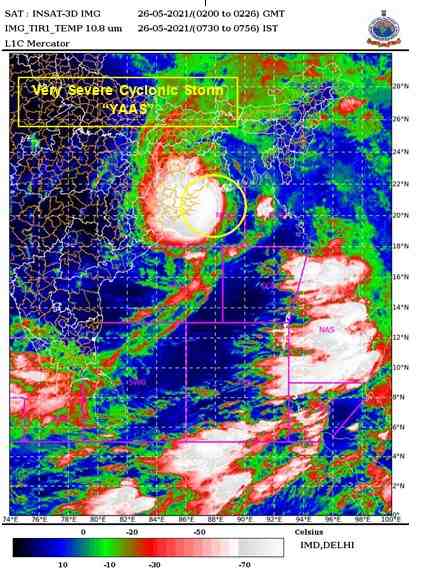
Very severe cyclonic storm Yaas centered about 50 less South-Southeast of Balasore, Odisha.
Due to cyclone Yas, flights at Kolkata Airport will be closed from 8:30 am to 6:45 pm on Wednesday.
A very strong cyclone Yaas will hit the coast of Orissa in a few hours. Unlike Ampan, this state will be affected. The state administration has already taken several precautionary measures to avoid any damage. As part of that precaution, nine flyovers in Kolkata were closed on Wednesday morning.
These 8 flyovers are: Gardenrich flyover, Park Street flyover, Taratala flyover, Goriyahat flyover, AJC Bose Road flyover, Ma flyover, Chingrighata flyover, Ultodanga flyover. These have been closed since 8 am. However, the administration did not confirm how long the flyovers would remain closed.
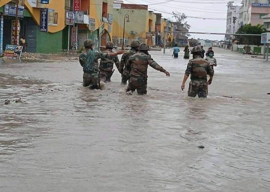
Rescue Operation after Cyclone Yaas
A part of Eastern command of Indian Army has been deployed for the rescue operation.
Rescue operation is also doing by NDRF.
Cyclone Yaas: Live Update on 25/05/2021
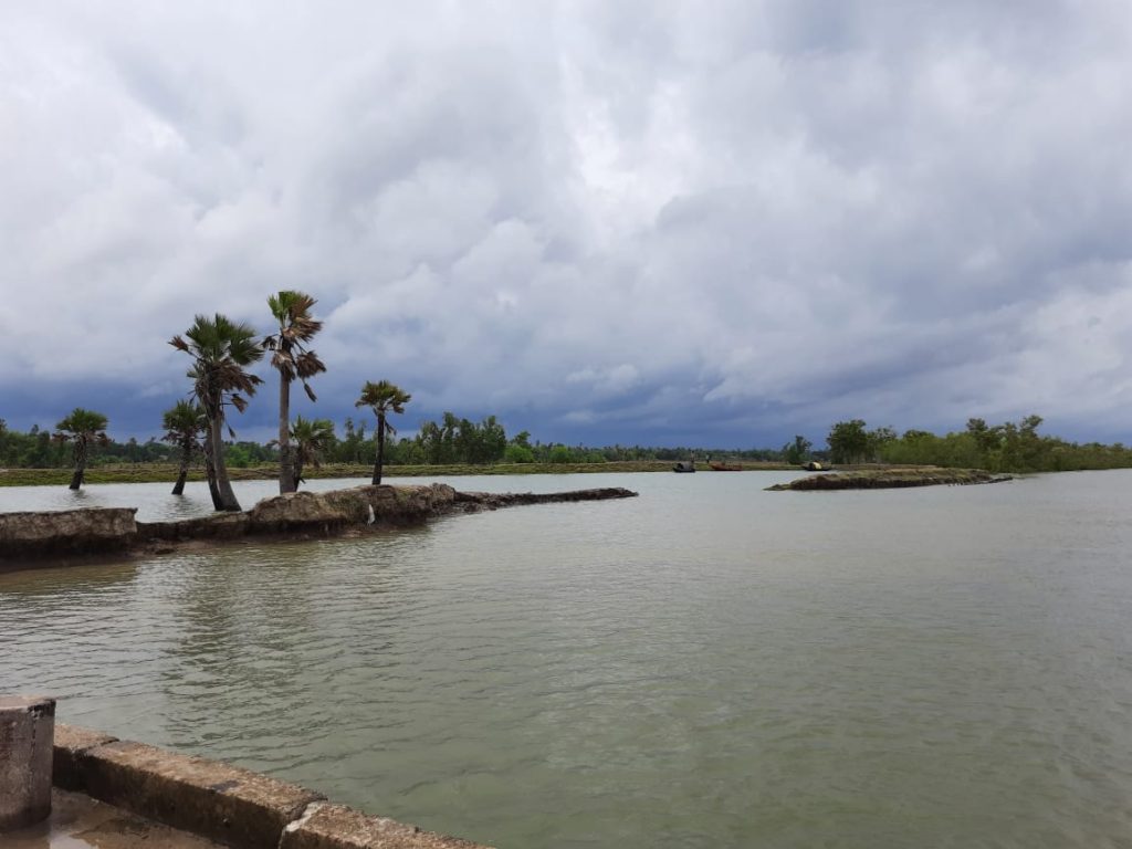
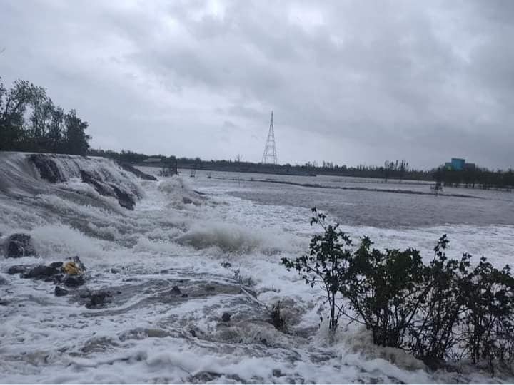
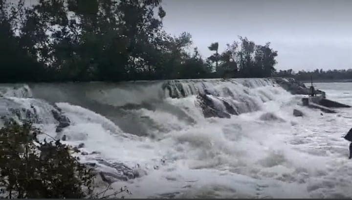
Water has already started flowing into the village by flooding dams in several coastal areas of West Bengal. As sea levels rise, so do the fears of coastal residents.
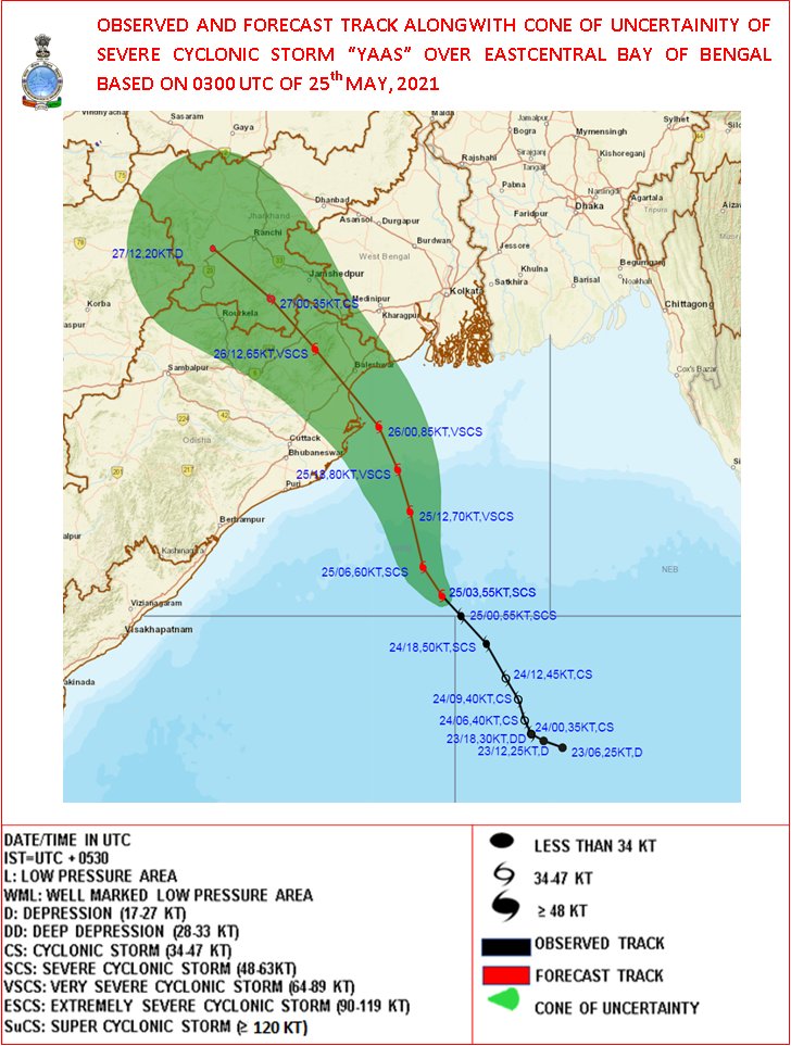
Strong cyclone Yaas is advancing towards the land by increasing the speed. According to the weather bulletin, Yaas has been advancing at a speed of 10 kilometers per hour for the last 8 hours.
At the moment, the cyclone is located 420 km away from Digha. Although the speed increases, the direction of Yaas is the same.
It is predicted that Yaas will pass through Baleshwar in Orissa between Paradwip in Orissa and Digha in West Bengal in the form of a very strong cyclone on Wednesday afternoon.

The cyclone formed in the Bay of Bengal is currently located at 16 degrees north latitude and 6 degrees 8 minutes east longitude.
At present, Yaas is located 320 km south-southeast of Paradwip in Orissa, 430 km south-southeast of Baleshwar in Orissa, 420 km south-southeast of Digha in West Bengal and 460 km south-southwest of Khepupara in Bangladesh.
Forecast is that Yass will pass through Baleshwar in Orissa in the form of a very strong cyclone on Wednesday afternoon. After that the cyclone will move towards Jharkhand.
The coastal districts of West Bengal, namely East Midnapore, West Midnapore, North 24 Parganas, South 24 Parganas, Kolkata, Howrah and Hughli, are receiving heavy to very heavy rains due to the impact of Yaas, the weather office said.
The storm could reach speeds of 155 to 165 km/h, with a maximum of 175 km/h, according to the Meteorological Department.
Cyclone Yaas: Live Update on 24/05/2021
Cyclone Yas has advanced further. According to the bulletin of the weather building, the cyclone is located at a distance of 720 km from Digha at 12 noon on Monday.
The storm is expected to reach 60 km per hour in the coastal areas of the state from Monday afternoon.
Yas has been advancing at a speed of 2 km per hour for the last 6 hours. The meteorological department said that the speed of the cyclone will increase as it moves towards the land.
The cyclone that formed in the Bay of Bengal is currently located at 16 degrees 4 minutes north latitude and 69 degrees 6 minutes east longitude.

Cyclone Yaas status on 23/05/2021
- Yaas is gradually increasing in strength and concentrating.
- It is now located 650 km south and southeast of Digha of West Bengal.
- Yaas will hit an area between Paradwip and Sagar Island by Wednesday evening.
- Yaas will take the form of a cyclone on Monday. In the afternoon, strong winds of up to 60 km per hour can blow in the sea.
- Yaas will then advance further towards the coast in the Bay of Bengal through the north-northwest.
- The wind can blow at a speed of 60 to 70 km/h. Light to heavy rains is forecast in two coastal villages of Midnapur, two 24 Parganas, Howrah and Hugli of West Bengal.
- Rain will increase from Wednesday with wind speed. An orange alert has been issued. Alipore is forecast to have a maximum wind speed of 155 to 165 km/h on that day.
- The highest rainfall is forecast in Kolkata, Jhargram, two Midnapore, 24 Parganas, Howrah, and Hughli of West Bengal. There is a possibility of heavy rain in Nadia, Burdwan, Bankura, Purulia, and Birbhum.
- Apart from this, scattered rains will also continue in Malda, Murshidabad, and South Dinajpur.
- The low pressure created in the East-Central Bay of Bengal on Saturday has increased to a specific low pressure on Sunday.
- According to the meteorological office, strong winds of 40-50 km/h are expected along the coast of West Bengal and Orissa from Monday evening.
- Yaas is likely to hit the coastal region of West Bengal and Kolkata on Wednesday evening.
- According to IMD, the wind will blow at a speed of 90-100 km/h from Wednesday morning.
- There will be heavy to very heavy rains in several districts of South Bengal, India.
- The meteorological office said that the speed of the cyclone could be 155-165 km per hour when it hits the ground.
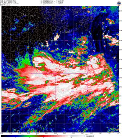
Cyclone Yaas status on 22/05/2021 (14:00 IST)
Indian Meteorological Department has been forecasted that over East-Central of Bay of Bengal, a low-pressure area has formed today morning.
This will be more intensified further.


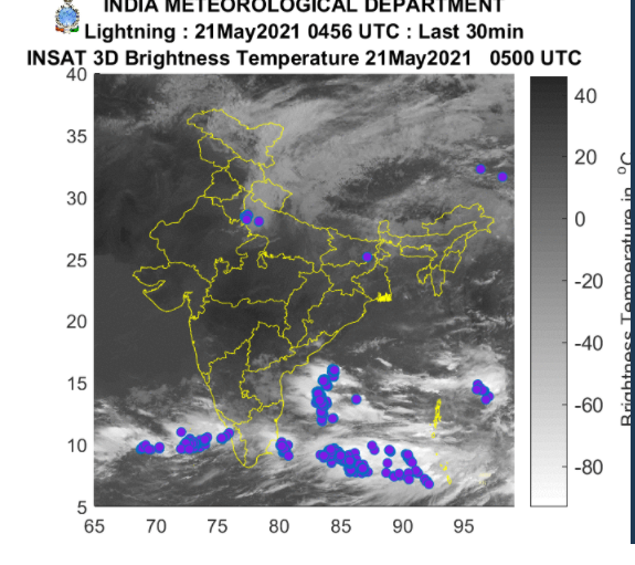
Cyclone Yaas status on 21/05/2021


Sea Level Condition during Cyclone Yaas
Due to the change in the weather, the sea will also start to rise from May 21. By 23 May, the sea in the Andaman Sea and the adjoining East Central Bay of Bengal will be in a very bad state.

During this time waves of up to 8-9 meters can be formed. Between May 24-26, the height of the wave can be up to 9-14 meters. The sea conditions along the coasts of West Bengal and Orissa will remain bad between May 25-26.
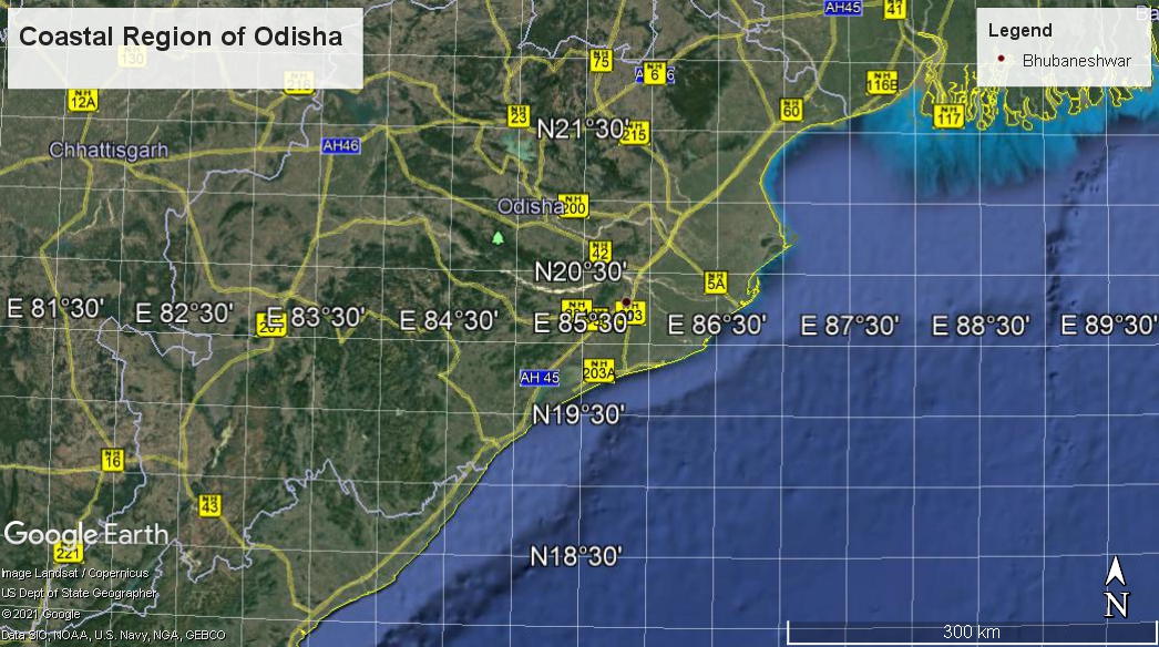
Cyclone Yaas in Odisha: Live Updates
According to the Odisha government, preparations have already begun to tackle Yash. Disaster response forces have been instructed to be ready.
Earlier, people were evacuating from 11 districts of Orissa during this war time. Puri, Jagatsinghpur, Kendrapara, Bhadrak, Balasore, Mayurbhanj, Gajapati, Ganjam, Khurda, Cuttack and Jajpur are the districts from where peoples are evacuating.
Kolkata Airport and Bhubaneswar airport is going to close. Partial effects of the storm are also felt in Srikakulam, Vijayanagaram and Visakhapatnam in Andhra Pradesh.
Why Cyclones are Coming Frequently?
At the same time, scientists are blaming global warming and climate change for so many storms.
Due to global warming and the neutrality of El Nino, marine environments are also becoming overheated. In the Indian Ocean, for example, the temperature was a couple of degrees warmer than normal.
For all these reasons, storms are being created here fast. Many of them are growing up later, many are not growing anymore.
For the same reason, the Bay of Bengal becomes deadlier. In details click Reasons Behind the Deadly Nature of ‘Bay of Bengal’
How Does the Weather Department Predict Cyclones?
Those who have experienced the devastating cyclone of the 1980s, say that the insect infestation has suddenly increased. And for a few days before the disaster, the dog was crying equally. The ants started climbing the tree with their eggs on their backs.
Before the invention of modern technology, people used to guess the message of the arrival of cyclones from their own experience. According to a Bengali article in Deutsche Welle, the cyclone was thought to be coming after seeing sultry weather, clouds, or rising water levels in the mouths of seas and rivers.
But now with the help of modern technology. Especially in the 1970s, when the use of artificial satellites (satellites) began to change. With the help of radar, aircraft, computers, etc., the location, intensity, size or structure of the cyclone is predicted.
When a satellite observes that region from just above a certain point on Earth, it is called a geostationary satellite. There are many such satellites. They send infrared images as well as visible images.
Infrared wave data play an important role in getting an idea of cyclone formation. And satellite images not only tell the location of the cyclone, they also give information about the intensity. Because meteorologists get an idea of wind speed by looking at some cloud patterns.
Although general information about the cyclone can be obtained from satellite images, the details have to be known directly. And the aircraft was sent to this work. This information is especially important for accurate warning. However, the United States only sends research aircraft if there is information that a cyclone could hit North America.
It is quite expensive for other countries. The collected data is then analyzed in a computer and predicted. The alarm was issued accordingly.
Which Countries are Giving the Name of Cyclones
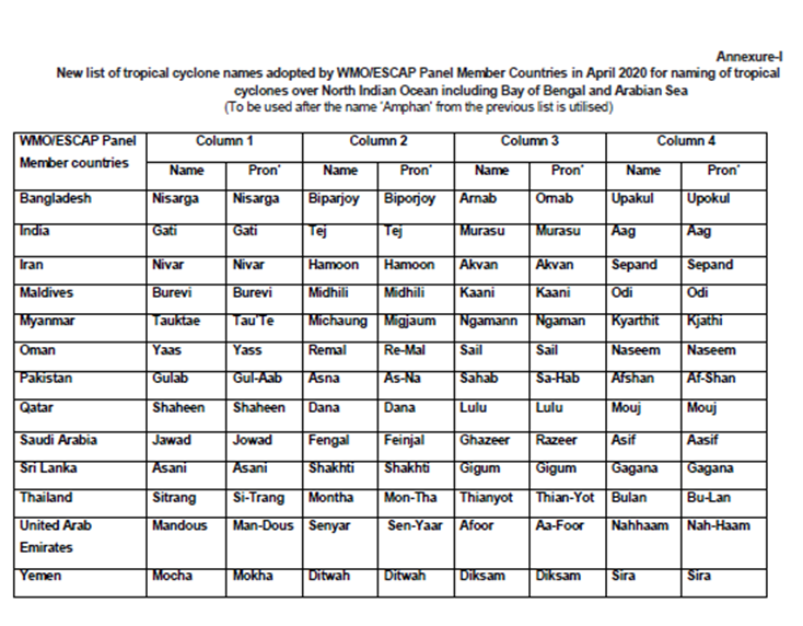
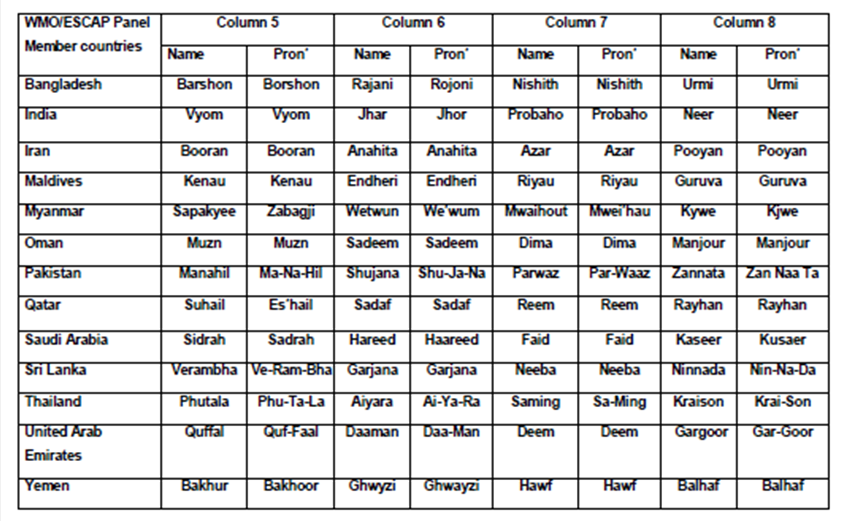
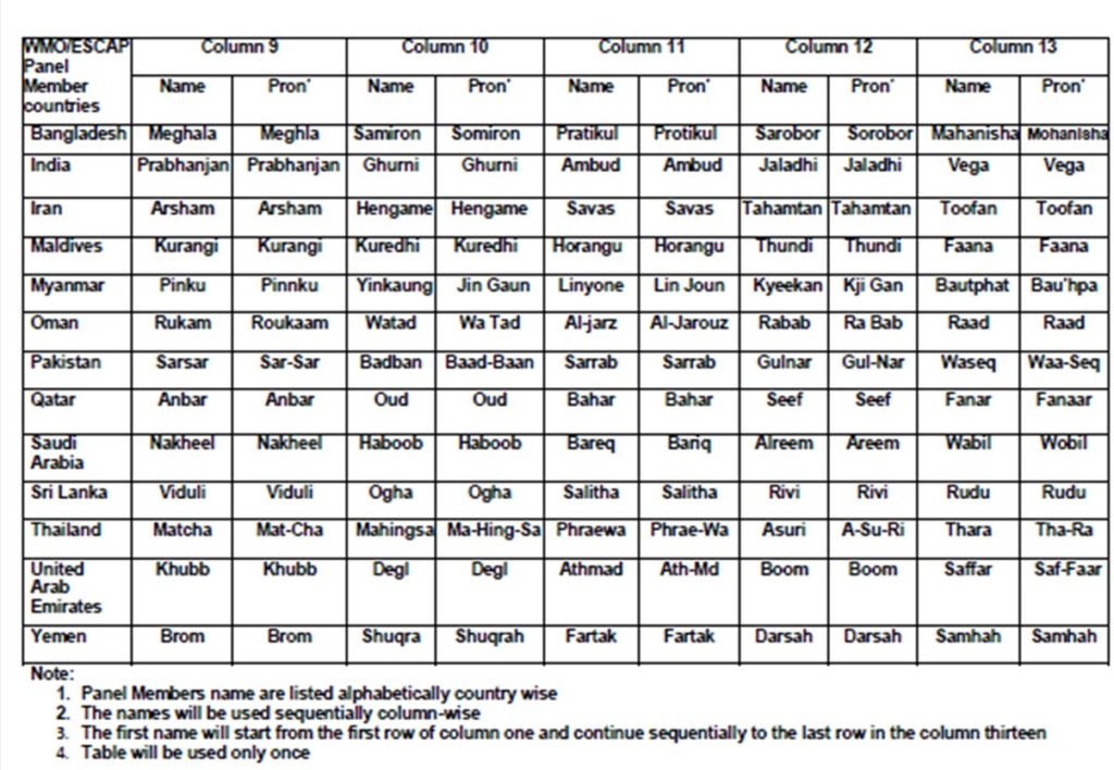
According to international law, the oceans that form a cyclone are named after the countries of the basin. Accordingly, the World Meteorological Organization / United Nations Economic and Social Commission for Asia and the Pacific (WMO / ESCAP) named the cyclone that originated in the Bay of Bengal and the Arabian Sea.

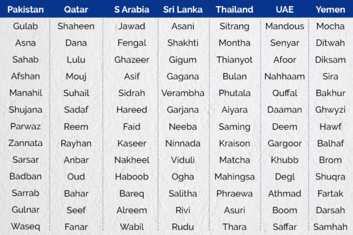
Similarly, the naming of the cyclone that originated in the Bay of Bengal and the Arabian Sea. At present, the organization has 13 members including India, Iran, Maldives, Bangladesh, Myanmar, Oman, Pakistan, Qatar, Saudi Arabia, Sri Lanka, Thailand, the UAE, and Yemen. For example, IMD or Mausam Bhavan sends the list of names on behalf of India.
The Indian Meteorological Department (IMD) names tropical cyclones in the northern Indian Ocean from 45 degrees east to 100 degrees. Cyclones that last at least three minutes in the air and have a minimum speed of 63 kilometers per hour are named by the 13 countries listed in the new 2020 list.
13 countries have prepared a list of 179 names with 13 names each. As such, cyclones are getting names in phases.
Nomenclature of Cyclone ‘Yaas’ and it’s Meaning
This time, the name of the cyclone has been given by Oman, in the Middle East.
The meaning of the ‘Yaas’ is disappointment or despair.
List of Upcoming Future Cyclones
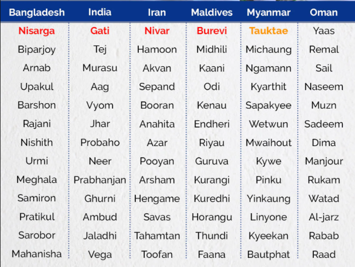
I list of upcoming cyclones has been published by the Indian Meteorological Department (IMD) and mentioned as below.
Prediction about Cyclone ‘Yaas’
After the cyclonic storm ‘Tauktae’ which affected the west coast of India, now, the east coast of India likely to be hit by cyclone ‘Yass’. IMD forecasted that “Light to moderate rainfall at most places with heavy falls at isolated places very likely to commence in the coastal districts of West Bengal from 25th May with a significant increase in spatial extension and intensity subsequently over the districts of Gangetic West Bengal.”
DR. R K Jenamani, a senior scientist of IMD told that “The formation of cyclone Yaas will be forming by May 22 in the north of Bay of Bengal. It is likely to move in the northwest direction and will form into a complete cyclonic storm by May 26. By the evening of May 26, it will hit Odisha and West Bengal coast.”
However, Alipore Meteorological Department at Kolkata could not give a clear indication of how strong it would be. Sunitha Devi of IMD told that “We cannot rule out an Amphan-like intensification. The only good thing is that models as of now are showing that the system is moving very fast over the sea. Its intensification will be restricted if its time over sea is less.” On 22 May 2021, IMD will forecast the wind speed and the landfall of the cyclone.
However, the wounds of last year’s cyclone Amphan are still scarring, so the state government is already making all preparations. Guidelines are issued by Government for all district administrations in the state on how to deal with the aftermath of the cyclone.
Preperation for Tropical Cyclone ‘Yaas’
- The guidelines say all those on leave are being canceled for the time being due to the threat of cyclones.
- District and block-level control rooms should be kept active 24 hours a day.
- The Disaster Management Force will be in constant touch with the concerned departments including Irrigation, Agriculture, Fisheries, Food, Electricity, and Health.
- If the mobile connection is cut off in any area due to a cyclone, it is necessary to keep in touch with the telecom companies so that it can be fixed quickly.
- In areas where cyclones are feared, people must be evacuated before the rains begin.
- They have to make arrangements to stay in the local school college.
- Relief materials such as dried food, packets of water, and triple should be stored in the relief camp.
- Sanitation arrangements have also been made at the relief camp in the Covid situation.
- A ‘quick response team’ should be formed for quick rescue in those areas.
- Besides, fishermen have been asked to take immediate steps to stop going to sea. Coast guards have been asked to monitor the airspace to see if anyone is in the deep sea.
- All the fishing boat at sea has been instructed to reach safety by May 23. New bans have been imposed on rivers and seas.
- The district administration has been asked to set up a separate repair team in case of falling trees, breaking of dams, or power outages.
- However, adequate masks and PPE kits have been requested for the disaster response forces in the Covid situation.
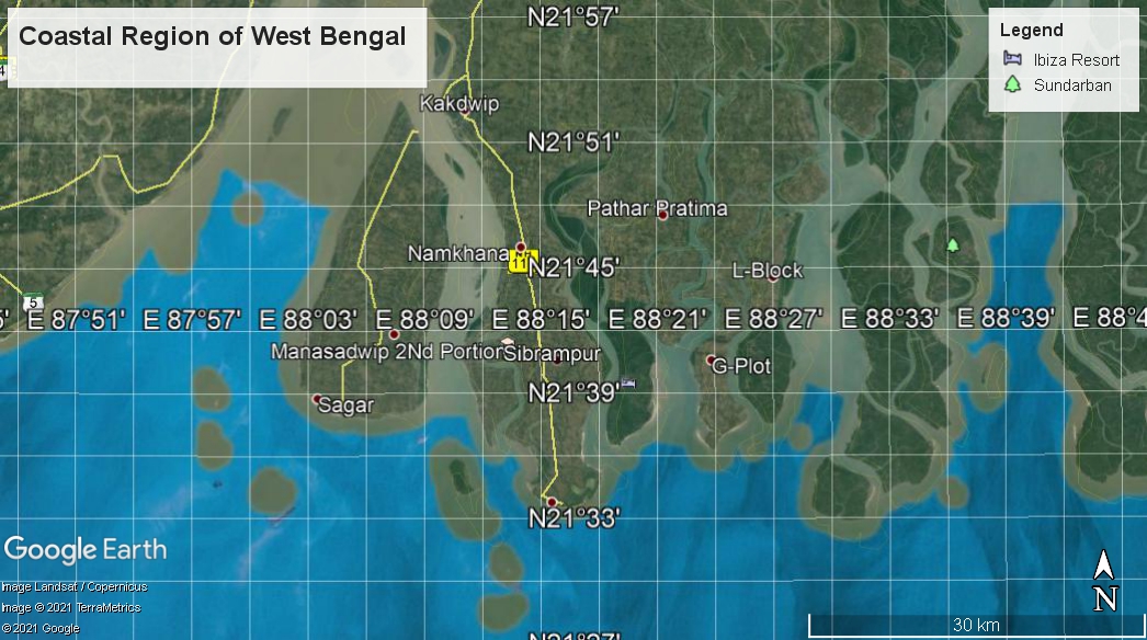
West Bengal (India) Administration is Busy Preparing for the ‘Yash’
- Cyclone Amphan hit the Corona episode last time. Hurricane ‘Yash’ could hit the second wave of COVID-19. In such a situation, the South 24 Parganas district administration is going to deal with ‘Yash’ keeping in mind the experience of ‘Amphan‘.
- Keeping in mind the horrible memories of that day, the district administration wants to make all kinds of arrangements before the arrival of ‘Yash’.
- According to district administration sources, Additional District Magistrate, 3 District Superintendents of Police, Sub-Divisional Magistrate, BDO, Chief Health Officer, Public Health and Technical Department, Disaster Management Department officials are holding regular meetings with District Magistrate P Ulganathan.
- All the emergency departments have been asked to start work immediately from now on Preparations are being made to evacuate all the people in the coastal areas before the storm. In addition to this, arrangements are being made to comply with the Covid rules in the disaster response centers keeping in mind the ‘Corona storm’.
- The district administration has already decided to open a total of 115 cyclone centers in Sagar, 10 in Kakdwip, 20 in Pathar Pratima, 18 in Namkhana, 5 in Mathurapur No. 2 blocks, 19 in Gosaba, 19 in Basanti and Kultali.
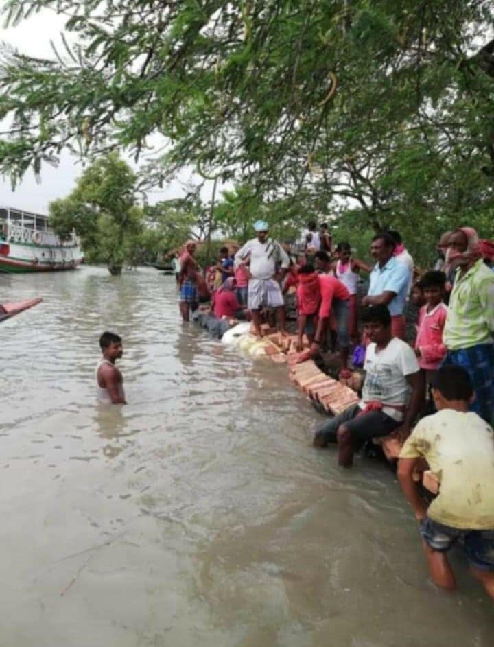
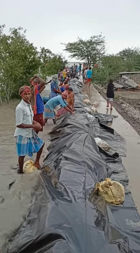
- Damage to river and sea dams in the Sundarbans has also begun to be repaired quickly.
- Each block has been instructed to stockpile relief items including adequate food, triple. District Magistrate Ulganathan said, “The whole situation is being monitored. All kinds of advance preparations are being made. Police, Coast Guard, Public Works, Public Health and Technical, Irrigation and Power departments will coordinate to deal with the disaster.
- Sundarbans Development Minister Bankim Hazra said, “The district administration is taking all necessary measures to deal with possible disasters as directed by the chief minister.”
- Cautionary campaigns are being carried out in the coastal areas of the Sundarbans. Fishermen are being warned by miking. Mike-propaganda has been in full swing in the port areas of Kakdwip, Namkhana, Frazerganj, Raydighi, and Patharpratima since Thursday (13/05/2021).
Expected Impact of Cyclone ‘Yaas’
Most of the cyclones originated at Bay of Bengal, had the severe impact on India and Bangladesh.
One year ago, we have experienced the devastating effects of Amphan in West Bengal of India and Bangladesh. With an average wind speed of 185km/h (115mph), Amphan gusted up to West Bengal and Odisha, states of India and Bangladesh. It took 128 life in India and caused damage of thousand crores.

This time it is also predicting that the wind speed may be more than Amphan’s what it has been in the last time. Therefore, the coastal regions may be affected severely due to heavy rain, storm, flood, etc. At this time, it is too early to predict this as the model will be developed upon the intensification within Saturday (22/05/2021).
What to do, What not to do during Cyclone Yaas
- Ordinary people also need to be careful before cyclone Yaas hits the land.
- Disaster has already come down with Covid-19. This natural disaster has a lethal effect on that existing situation. So it is better not to listen to any rumors.
- Instead, we need to keep an eye on the weather and administrative warnings published on radio, television, and in the media.
- Electricity poles have to be tested. Yet for the sake of safety, the common man should take several precautions.
- For example, there is a risk of power outages due to storms and rains. In that case, mobile phones and power banks need to be charged in advance.
- Beware of broken electric poles, damaged wires, and sharp objects on the road.
- Essential supplies, food, medicine, and water should be kept at hand.
- People should take shelter in local cyclone shelters or in concrete houses to protect themselves from disasters in coastal areas.
- At the same time, important documents and valuables should be safely removed from the water.
- The state power department of West Bengal has launched two helpline numbers, 6900693503 and 8900693504, to deal with the cyclone. Helpline number two will be operational from May 25. Therefore, for any help, communicate as far as possible.
Why are Cyclones Frequently Originating at Arabian Sea and Bay of Bengal, in this Decade?
Until a few years ago, the Bay of Bengal was considered to be prone to cyclones in the northern Indian Ocean region (the Bay of Bengal and the Arabian Sea). But with 117-year-old records being broken and four very powerful cyclones forming in the Arabian Sea in 2019, meteorologists are fairly convinced that the old theory of cyclones is no longer valid.
Because the recent cyclone has not only destroyed houses, it has also shattered all old stereotypes about storms!
Some meteorologists were skeptical about the warming of the Arabian Sea. But two years ago, a series of very strong cyclones (Vayu Severe Cyclone) ‘Vayu’ and ‘Hika’, super-powerful Cyclone ‘Maha’ and super cyclone ‘Kear’ were formed in the Arabian Sea.
Analyzing the data of the weather department, the meteorologists found that even 15 years ago, if an average of five cyclones formed in the northern ocean area a year, all four of them would occur in the Bay of Bengal. In the Arabian Sea. But over the years, that has changed.
That change was reflected in the country’s climate report published last year by the Central Meteorological Department (Indian Meteorological Department or IMD). It said five of the eight cyclones that hit the country in 2019 (four of which were extremely strong) formed in the Arabian Sea. Such incidents happened in the past only in 1902!

Meteorologists are blaming warming and climate change for this. Analysis of the IMD report shows that not only the sea level, but also the surface air temperature (land surface air temperature) has gradually increased.
That is why 2009-2019, 2015, 2016 and 2017 were the warmest years in these eleven years. And the last two decades, 2001-’10 and 2010-’19, were the warmest ever.
Earlier, the sea surface temperature in the Arabian Sea was 0.5-1 degree Celsius lower than in the Bay of Bengal. But now, thanks to warming and climate change, that warming has become almost like the Bay of Bengal. As a result, not only the same number of cyclones has been created, it is also seen that the cyclones created in the Arabian Sea are becoming more prevalent than the cyclones created in the Bay of Bengal.
According to the Central Meteorological Department, the lowest cyclone was formed in 1949 in the northern Indian Ocean region, the Bay of Bengal, and the Arabian Sea combined. Only one. The worst cyclones were in 1893, 1926, 1930, and 1964. In all those years, 10 cyclones formed in the Bay of Bengal and the Arabian Sea.
According to a scientist at the Indian Institute of Tropical Meteorology, 35 % of the low pressure created in the Bay of Bengal and the Arabian Sea a few years ago was cyclones, 18 % strong cyclones, and 6 % very strong cyclones.
But in the current situation, the tendency of very strong and very strong cyclones has increased.
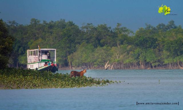
How to Protect Sundarban and Coastal Regions from Severe Cyclones?
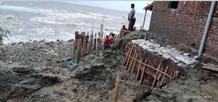
Such fears have been raised in coastal areas of the state, including Mandarmani. This disaster is not the end. Such dangers will increase in the future.
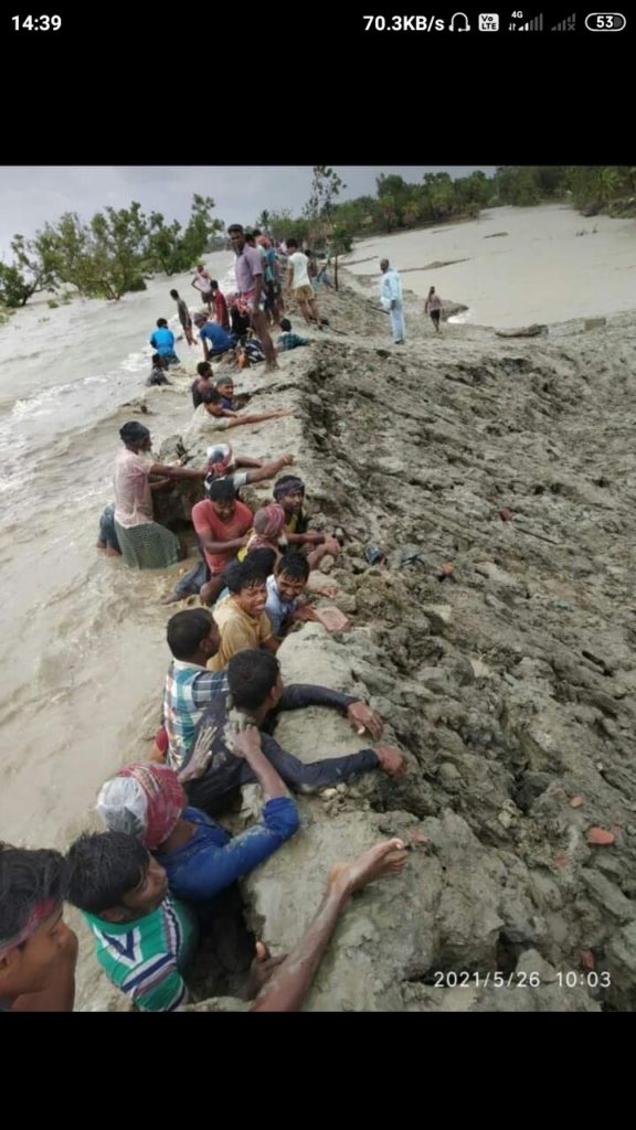
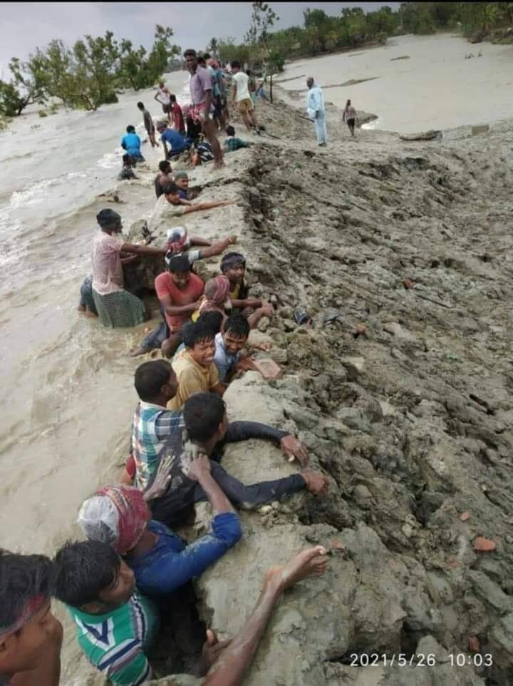
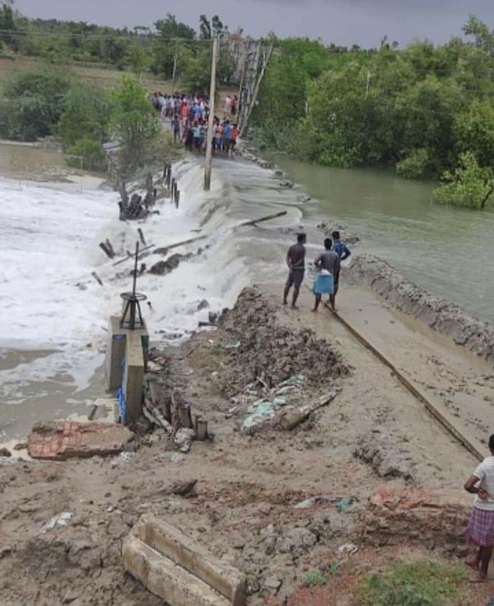
The danger that artificial dikes alone cannot prevent has been proven time and time again. Many scientists have questioned why the dam is easily fragile. The question is, what about destroying mangroves in the name of building dams on the river.
A decade ago, when the Coastal Regulatory Zones Act was enacted, scientists called for a joint attack of cyclones, tides and catastrophes. Dangerous areas on the coast were identified accordingly. But all has been ignored.
There were natural dunes in the area including Mandarmani. The tidal wave was the bulwark to survive the storm. Now they have to pay compensation for destroying them in the name of tourism. A section of the environment department also agrees that hotels and resorts have been set up on the beaches of the state, including Mandarmani, in violation of the rules. There have been lawsuits about this. But even after that, for some unknown reason, they were still going strong.
Global warming and rising sea levels are global problems. Its influence is greatest in the Bay of Bengal and the Sundarbans. On one side the water level is rising, on the other side, the newly formed delta is settling. As a result, the overall water level is rising much higher. As the sea warms up, cyclones are forming more and more.

Questions are also being raised about the destruction of mangroves in the Sundarbans. Planting a mangrove tree next to an earthen embankment protects its roots from washing away the soil.
Such dangers are coming again and again. To avoid this, emphasis should be laid on forest creation. In the Sundarbans, mangroves are a safe haven. This heaven should be protected.
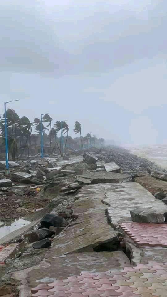
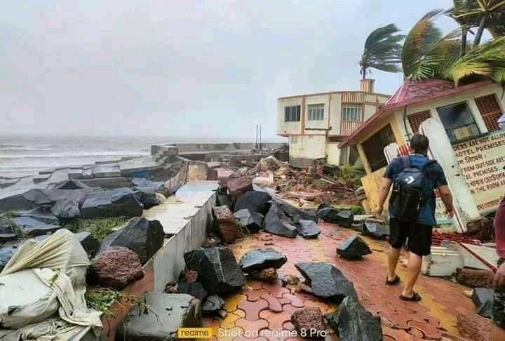
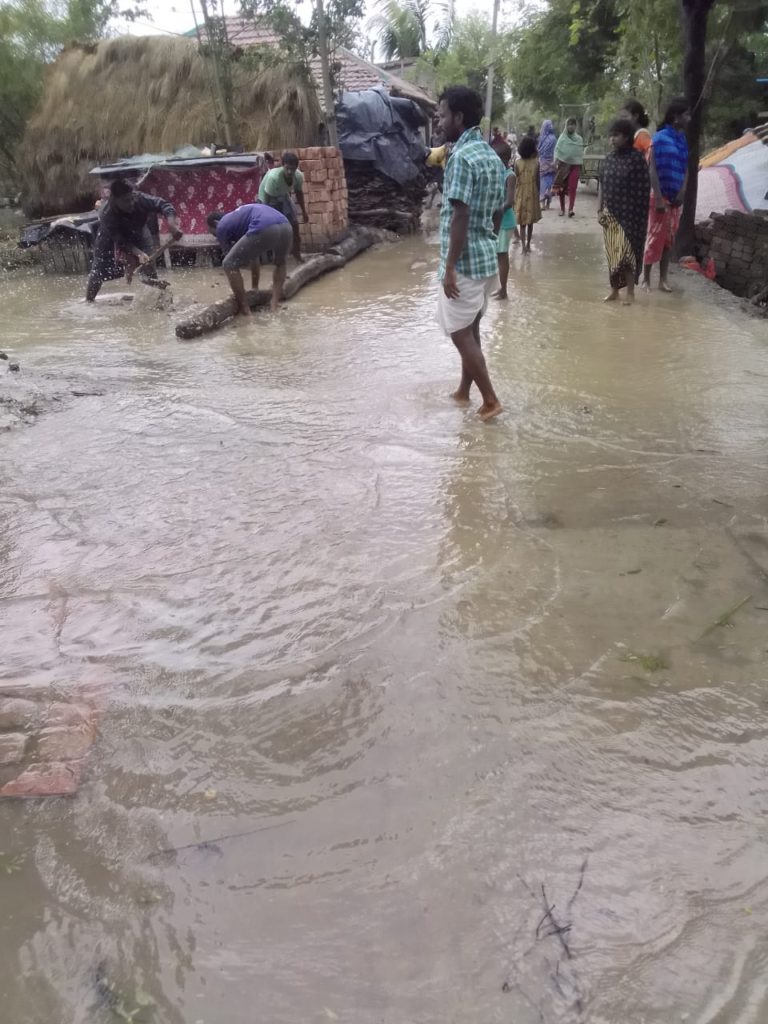
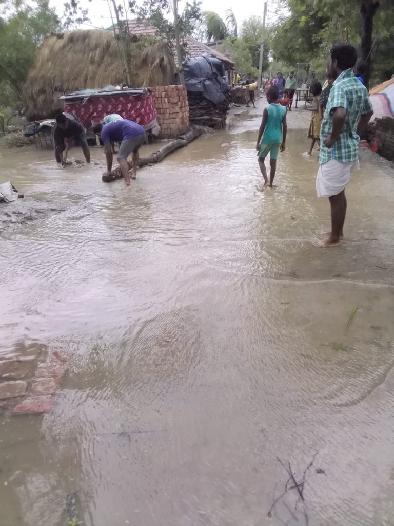
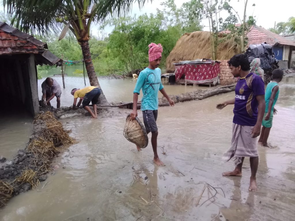
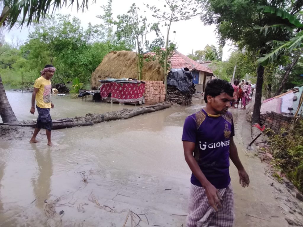
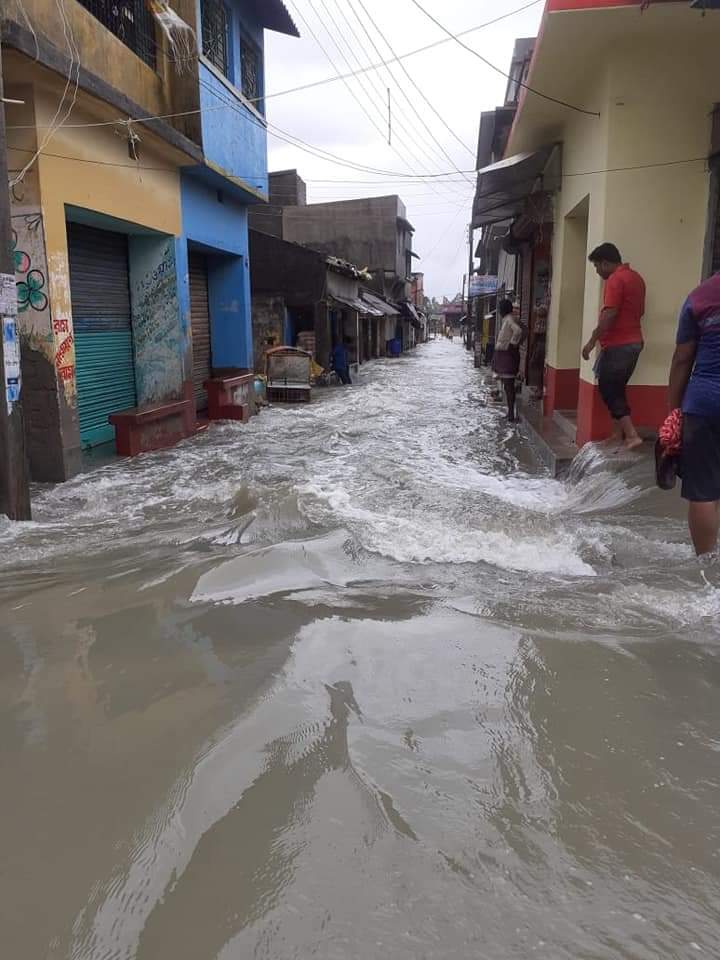
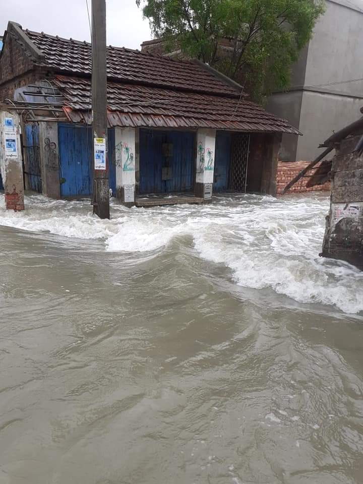
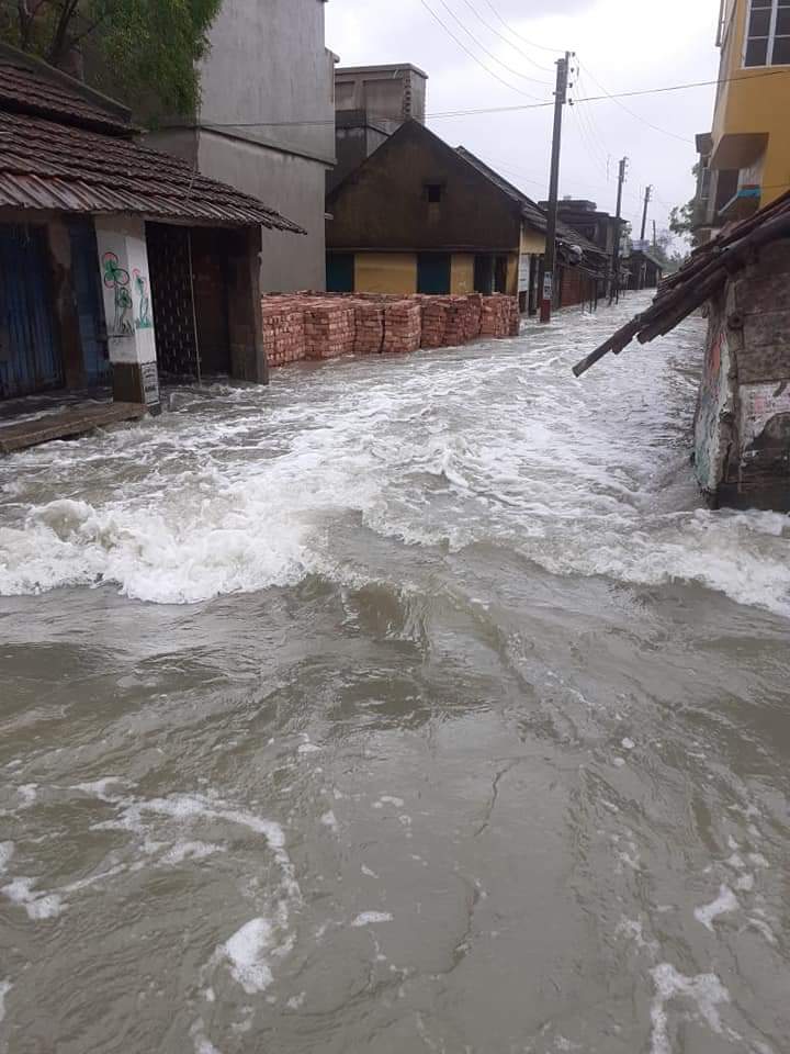
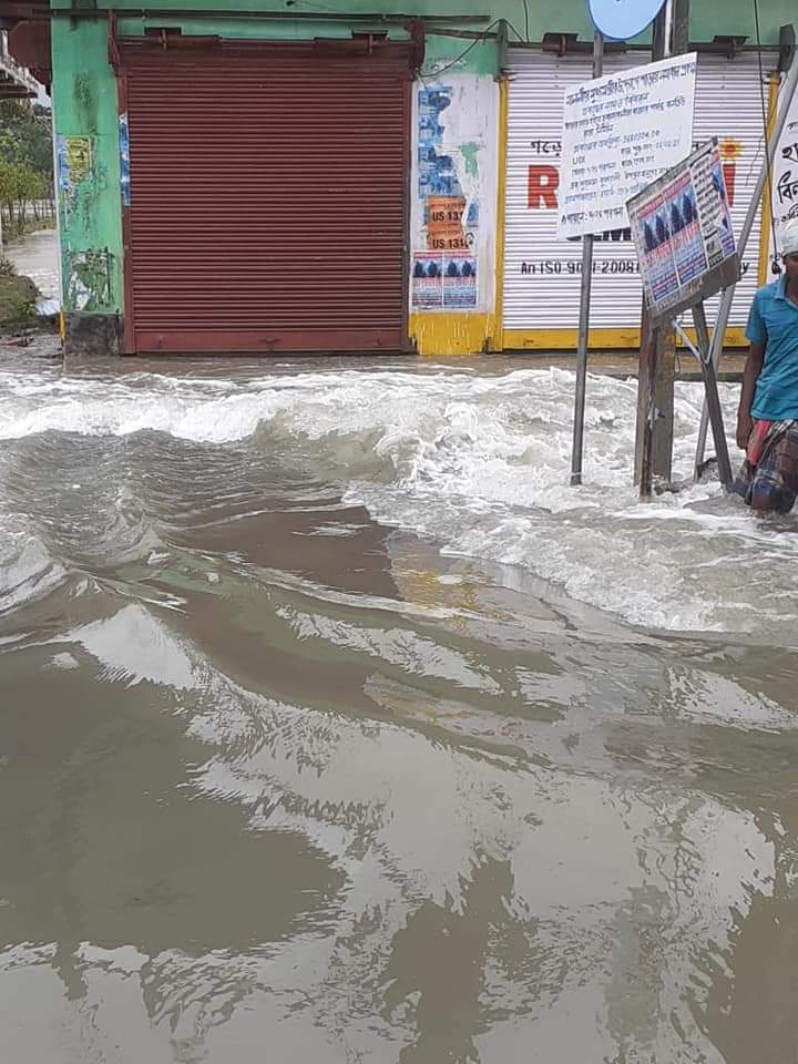
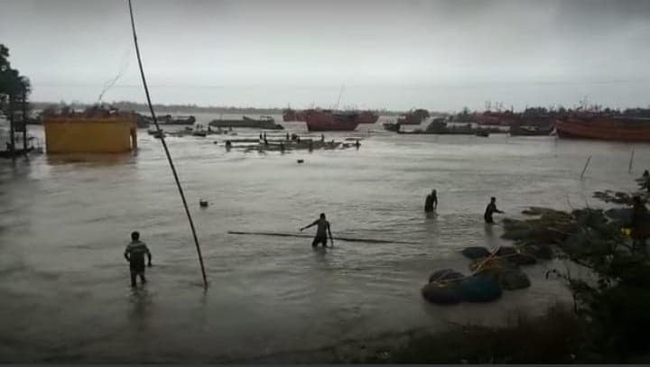
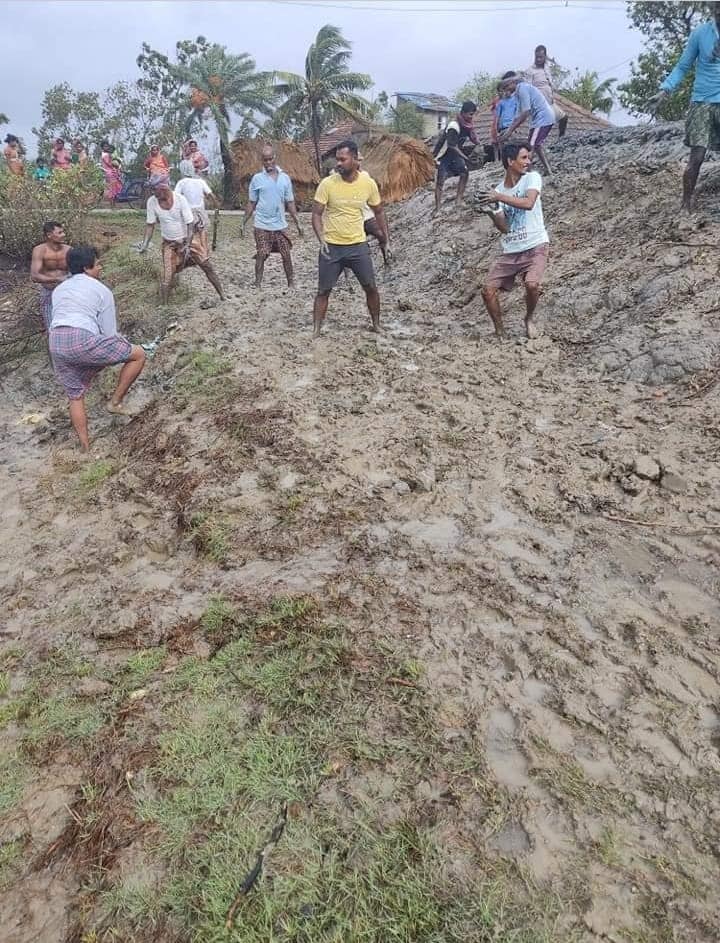
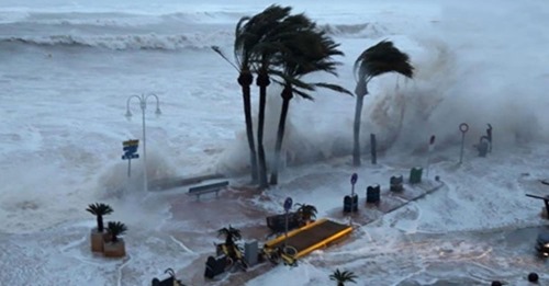
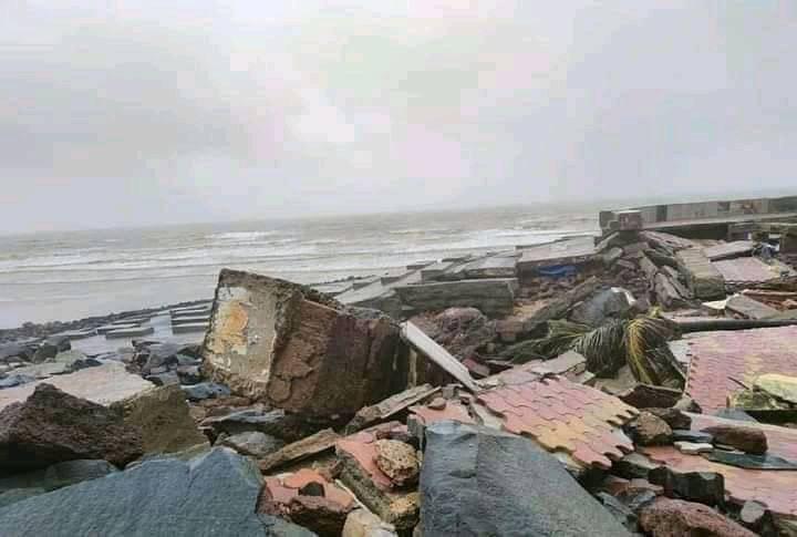
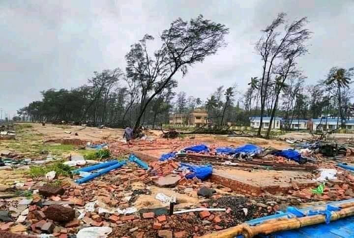
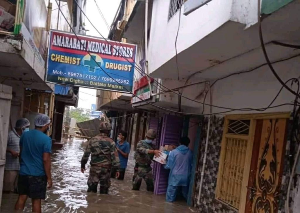
Videos of Cyclone Yaas
Pictures on Effect of Cyclone Yaas

Relief Package By Government of India after Cyclone Yaas
Union Home Minister Amit Shah has announced Rs 600 crore in financial assistance to Orissa and Andhra Pradesh to deal with the cyclone situation. He also said that Rs 400 crore has been allocated for West Bengal.
Relief Package By West Bengal after Cyclone Yaas
The relief money will be given only after understanding the extent of the damage, Chief Minister Mamata Banerjee said. Mamata also said, depriving the poor so that government money is not misused, we have to keep an eye on it.
Mamata said, “The relief program will continue from June 3 to June 18. There you can apply for your own loss. After that, from 19 to 30 June, the administrative officials will look into the relief application.” The survey will look at whether the application is appropriate. “Whether the relief money will be paid or not will be decided after the survey,” Mamata said.
Mamata said the decision was taken to prevent misuse of government funds. “Relief money will reach the recipients through bank drafts from July 1-6,” she said.
This time the West Bengal Government announced compensation for the victims of Cyclone Yaas. Compensation for farmers, fishermen and handicrafts men has been announced from a minimum of Rs 300 to a maximum of Rs 30,000.
- Farmers will get a minimum compensation of 1 thousand rupees in case of crop loss. Maximum will be 2500 Rs.
- The government will pay Rs 20,000 per family to those whose houses have been destroyed by the cyclone. If the house is partially damaged, Rs 5,000 per family will be paid.
- If the cattle died in the cyclone, each cow and buffalo will be compensated 30,000 rupees, so that the cattle can be bought again with that money.
- If the sheep, goat and pig have died, 3 thousand rupees will be paid for the new purchase.
- If a bull used for farming or carrying goods dies in a disaster, Rs. 25,000 will be paid for each one.
- If the calf has died, it will be 18 thousand rupees.
- Whatever the size, the farmers will get 5 thousand rupees if the drinking waste is damaged in the disaster.
- They will also get 2,600 rupees to buy fishing nets. If the boat is completely damaged by the storm, 10 thousand rupees will be paid for each boat. If the boat is partially damaged, they will get 5 thousand rupees.
- The state government will pay 4,100 rupees per head to buy handicrafts equipment. They will also get 4,100 rupees per head to buy raw materials. If the warehouse, shop or storage place is damaged by the storm, Rs 10,000 per unit will be paid.
The ‘Relief at the Door’ camp is opening from June 3. Applications can be collected from 3 to 16 June. The damage will be reviewed between June 19 and 31. After that, between July 1 and July 7, the state government will deposit the compensation money in everyone’s account.
Frequently Asked Questions (FAQ)
Cyclone ‘Yaas’, another natural anniversary disaster like Amphan, is coming on 26th May 2021.
Cyclone ‘Yaas’, another natural anniversary disaster like Amphan, is coming on 26th May 2021.
Indian Meteorological Department has forecasted that over the East-Central of Bay of Bengal, a low-pressure area has formed today morning.
Fanoos, Yemyin, Sidr, Nargis, Rashmi, Nisha, Aila, Laila, Jal, Thane, Nilam, Helen, Lehar, Phailin, Hudhud, Komen, Roanu, Vardah, Mora, Ockhi, Titli, Gaja, Fani, Bulbul.
Cyclone ‘Yaas’, another natural anniversary disaster like Amphan, is coming on 26th May 2021.
Cyclone ‘Yaas’, another natural anniversary disaster like Amphan, is coming on 26th May 2021.
Cyclone ‘Yaas’, another natural anniversary disaster like Amphan, is coming on 26th May 2021.
Cyclone ‘Yaas’, another natural anniversary disaster like Amphan, is coming on 26th May 2021.
Cyclone ‘Yaas’, another natural anniversary disaster like Amphan, is coming on 26th May 2021.
About the Author
The author is Dr. Arup Giri, Associate Professor of Baba Mastnath University, Rohtak, Haryana, India. To know more about him, you may follow the links.
Pingback: Bay of Bengal; The Motherhouse of Tropical Cyclones- Hurricane
Something very scary 🤔But things are changing frequently in the ocean bed, warming water, and resulting into hotter wind…so many cyclones in Indian Ocean….need more research
👆 Just wondering